Quick guide to find the walking time between places
X
wikiHow is a “wiki,” similar to Wikipedia, which means that many of our articles are co-written by multiple authors. To create this article, volunteer authors worked to edit and improve it over time.
This article has been viewed 51,031 times.
Learn more...
Google Maps can be a useful tool to navigate through a new location or place. You can also use it to get directions and possible transportation options. If you plan on walking, you can use Google Maps to get an idea of how long it will take you to get to your destination. Knowing your transportation options before going out can make your life much easier.
Steps
Method 1
Method 1 of 2:
Finding the Walking Distance on the Google Maps Website
-
1Go to Google Maps. You can use any web browser on your computer to visit this site.
-
2Identify your destination. Use the search box on the upper left corner of the page and type in your destination location or address. A shortlist of possible results will drop down.
- Click on your selection, and the map will automatically draw you to the location you’ve set.
Advertisement -
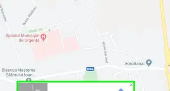
3Identify your starting location. Go back to the section on the upper left corner of the page. The destination you’ve set is displayed there. Click on the “Directions” button beside it, and a new field will appear where you can type in your starting location or address.
- A shortlist of possible results will drop down. Click on your selection, and the map will automatically expand to show you the route from this starting location to your destination.
-
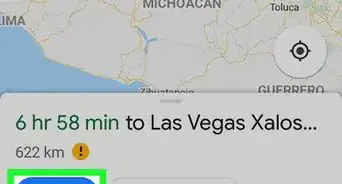
4Click on the pedestrian (walking) icon on the toolbar above the section. This should be on the upper left corner of the page. The route on the map will slightly change to accommodate your preferred method of transportation.
-
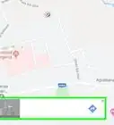
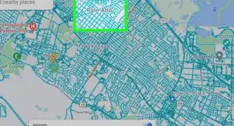
5Find the walking distance. On a spot on the route, there’s a small box with the pedestrian icon. Inside this box, the total walking distance from your starting location to your destination is indicated. The duration is also clearly listed. Based from these data, you will know how far and how long you have to walk.


Advertisement
Method 2
Method 2 of 2:
Finding the Walking Distance on the Google Maps Mobile App
-
1Launch Google Maps. Look for Google Maps app on your mobile device and tap on it.
-
2Identify your destination. Use the search box on the upper left corner of the page and type in your destination location or address. A shortlist of possible results will drop down. Tap on your selection, and the map will automatically draw you to the location you’ve set.
-
3Identify your starting location. Go back to the section on the upper left corner of the page. The destination you’ve set is displayed there. Tap on it.
- A new field will appear where you can type in your starting location or address. Tap on it and type in your location. A shortlist of possible results will drop down.
- Tap on your selection, and you will be shown the best transportation method and route from your starting location to your destination, with the total distance and time. Most of the time this will be via car or rail, since these are the faster options.
-
4Tap on the pedestrian (walking) icon on the toolbar above the section. This should be on the upper left corner of the page. The route on the map will slightly change to accommodate your preferred method of transportation.
-
5Find the walking distance. You will find the total walking distance and duration from your starting location to your destination on the upper left corner or on the bottom of your screen, depending on the orientation of your mobile device. Based from these data, you will know how far and how long you have to walk.


Advertisement


About This Article
Advertisement