X
wikiHow is a “wiki,” similar to Wikipedia, which means that many of our articles are co-written by multiple authors. To create this article, volunteer authors worked to edit and improve it over time.
This article has been viewed 112,960 times.
Learn more...
Google Maps' Street View can also be used to explore the world's oceans and dive underwater without leaving your seat. There are only selected underwater locations currently available, but the views are breathtaking. You can see lots of aquatic life and reefs from around the world. Street View is supported from Google Maps website from your web browser.
Steps
Method 1
Method 1 of 2:
Going Underwater through Location Search
-
1Go to Google Maps. Open any web browser on your computer and visit the Google Maps website.
-
2Identify a location. Use the search box on the top left corner of the page, and type in the underwater location you want; for example, Atlantic Ocean or Pacific Ocean. A shortlist of possible results will drop down. Click on the location you want, and the map will automatically draw to the location you've set.Advertisement
-
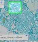
3Check if Underwater Street View is available. There aren't a lot of underwater locations available for street view, so to check if the location you entered has Street View, check the thumbnails that appear below the search bar. Locations with underwater Street View has an Underwater thumbnail.
-
4Go underwater. Click the Underwater thumbnail. The view on the screen will zoom into the water area and dive down.
-
5View underwater. The images captured from the underwater location will be displayed. Use your mouse to navigate through the images. Click and drag the screen to move around. Clicking on the arrows that will appear will move you to that specific area. It will feel like you're diving as you go past the fishes and reefs.
- If you want to exit the view and search for a new one, just click the arrow pointing left at the top leftmost area of the screen. You'll be taken back to the maps view of the location.


Advertisement
Method 2
Method 2 of 2:
Going Underwater through the Oceans View Page
-
1Go to Oceans View. Open any web browser on your computer, and go to the Google Maps Ocean View website.
-
2View the available Ocean View locations. The underwater locations currently available are displayed on the right panel of your screen. Each of the locations is identified by its name, location, and a thumbnail image. Use the scroll bar on the right to scroll through them.
-
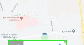
3View locations through the world map. A map of the world is also displayed on the lower left part of your screen. The locations that currently have underwater Street View are identified by the red dots.
-
4Select an underwater location. Click on either the thumbnail image on the right panel or on the red dot on the map to go to that underwater location.
-
5View underwater. The images captured from the underwater location will be displayed. Use your mouse to navigate through the images. Click and drag to move around. Click on the arrows that will appear to move further to a specific area. It will feel like you're diving as you go past the fishes and reefs.
- To exit the underwater view, just click the X at the top of the right panel.


Advertisement


About This Article
Advertisement