This article was co-authored by wikiHow staff writer, Janice Tieperman. Janice is a professional and creative writer who has worked at wikiHow since 2019. With both a B.A. and M.A. in English from East Stroudsburg University, she has a passion for writing a wide variety of content for anyone and everyone. In her free time, you can find her working on a new crochet pattern, listening to true crime podcasts, or tackling a new creative writing project.
There are 15 references cited in this article, which can be found at the bottom of the page.
This article has been viewed 42,062 times.
Learn more...
Whether you’re traveling or working on a landscaping project, it can be useful to know your elevation. If you’re looking for an exact number, use an altimeter, computer, or smartphone to calculate your current position above sea level. If you’re trying to find a difference in elevation between 2 points of land, use tie a length of string between two posts and use a level to determine the difference.
Steps
Determining Your Elevation Above Sea Level
-
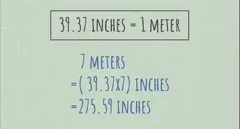
1Figure out your exact location with a navigational app. Open the Google Maps app on your smartphone or go the website on your computer. If you’re on a mobile device, tap and hold on a certain point of the map to show your current position in latitude and longitude. If you’re on a computer, right-click on the map to access your coordinates. Write these numbers down on a piece of paper, as they’ll come in handy later.[1]
- To make things easier, feel free to copy and paste your coordinates.
-
2Enter your coordinates into an online elevation calculator. Search online to find an online resource, like FreeMapTools. Use the dialogue box on the website to input your previous coordinates. After you’ve typed or copied the numbers into the search box, hit the enter button on your device. Check the webpage to see if your elevation measurement has appeared.[2]
- Many of these maps can determine your elevation by your address alone.[3]
- If the website doesn’t load correctly, try refreshing the page.
Advertisement -
3See if your elevation is above or below sea level. Look over your measurement to see how elevated you are. If the number is positive, then your location is that many feet or meters above sea level. If your measurement is negative, then you’re that amount of feet/meters below sea level.[4]
- Someone who lives near the mountains will be at a much higher elevation than someone who lives on the coast.


Surveying Land Elevation
-
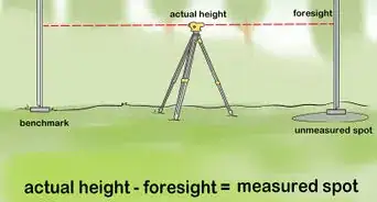
1Try to find 2-3 benchmarks in the area. Look around the plot of land to search for benchmarks, or objects that have a consistent elevation. Since the elevation of certain objects (e.g., trees, bushes) can change over time, try to choose a sturdy, unmoving object as a benchmark. If you’re working near a bridge or nearby building, try to determine the elevation of those locations by looking at a past land survey.[5]
- For example, if you’re measuring the elevation between 2 different points in your yard, try using the elevation of your house as a benchmark.
-
2Set up 2 metal posts between 2 different points on the land. Choose 2 different points in the land that you want to measure, and mark them in place with a stick or other sharp tool. Next, take 2 metal posts and insert them into the marked areas of soil. Follow the manufacturer’s instructions when you install the posts, and check to see if you need to dig any post holes ahead of time.[6]
- Although metal posts are more sturdy, you can also use wooden posts.
- Make sure that the posts are even in height after you place them in the ground.
-
3Tie a string between the 2 posts to determine the slope. Take the end of a string and tie it securely around the post. Unspool the string as you continue along until you reach the second post. Snip off the string and tie it to the second post. When you do this, make sure that the string is as taut and straight as possible.[7]
- Try using a durable string or cord for this.
- Be sure to note the total length between the 2 posts.
-
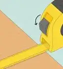
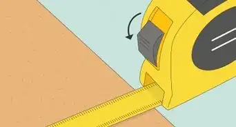
4Measure the height of the posts with a measuring tape. Place the bottom of a measuring tape at the foot of the metal post. Start where the post enters the ground, and stretch the tape to reach the top of the post. Write down or memorize this measurement, as it will come in handy later.[8]
- At this point, make sure that both posts are the same height. If either post is taller or shorter than the other, make adjustments as necessary.
-
5Hold a level in place beneath the center point of the string. Walk to the approximate center point of the string to continue your measurements. Place a 4 feet (1.2 m) level beneath the center of the string. To keep one side of the level snugly in place while you measure, set up a pile of stones a stack of bricks beneath the string.[9]
- If you don’t have a 4 feet (1.2 m) level on hand, use a different size. Whatever level you use, make sure you know what its length is for future calculations.
- A stack of bricks also work well to secure one side of the level.
-
6Adjust the other side of the level until it's centered. Start shifting the bubble portion of the level once the far side is secured into place. Move the level slowly until it reads a level measurement. As you do this, keep in mind that the level probably won’t be parallel to the string you’ve set up. Continue to check that the other side of the level is secure, as you’ll need both hands available for the next step.[10]
-
7Measure the distance between the unsecured end of the level and the string. Use the tape measure to calculate the distance between the end of the level and the string. Depending on your land, this distance could be several inches or centimeters. Take note of this number, as it you’ll need it to calculate the elevation difference.[11]
- If you’re not a fan of math, have a small notebook and a calculator on hand so you can keep track of your various measurements.
-
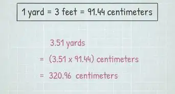
8Use the length of both your string and level to calculate the difference in elevation between your posts. Take the total length of your string and divide it by the length of your level. Since this number equals the total difference in elevation from each post, multiply this number by the calculated distance between the string and level. If you’re using the Imperial measurement system, divide this number by 12 to view the results in feet. If you’re using the metric system, adjust the decimal point accordingly.[12]
- For example, if the distance between your posts is 132 inches (340 cm), divide that length by your the length of your 4 ft (120 cm) level to get a total of 33 in (84 cm). If the distance between your posts is 2 in (5.1 cm), multiply 33 in (84 cm) by 2 in (5.1 cm), which gives you a total of 66 in (170 cm). That number would be your total elevation change, in inches/centimeters.


Things You’ll Need
Determining Your Elevation Above Sea Level
- Computer
- Smartphone
Surveying Land Elevation
- 2 metal posts
- Roll of string
- Level
- Tape measure
- Calculator
Warnings
- Watch out for altitude sickness whenever you travel to a place with a higher elevation.[15]⧼thumbs_response⧽


References
- ↑ https://m.youtube.com/watch?v=WRrArWdUqZs&t=0m47s
- ↑ https://m.youtube.com/watch?v=WRrArWdUqZs&t=2m19s
- ↑ https://www.calcmaps.com/map-elevation/
- ↑ https://m.youtube.com/watch?v=WRrArWdUqZs&t=3m6s
- ↑ https://acwi.gov/monitoring/conference/2016/2_wednesday_may4/E9F9/ElevationSurvey_secure.pdf
- ↑ https://m.youtube.com/watch?v=Zc660JkRuLg&t=1m11s
- ↑ https://m.youtube.com/watch?v=Zc660JkRuLg&t=1m23s
- ↑ https://m.youtube.com/watch?v=Zc660JkRuLg&t=1m46s
- ↑ https://m.youtube.com/watch?v=Zc660JkRuLg&t=3m27s
- ↑ https://m.youtube.com/watch?v=Zc660JkRuLg&t=3m40s
- ↑ https://m.youtube.com/watch?v=Zc660JkRuLg&t=3m47s
- ↑ https://m.youtube.com/watch?v=Zc660JkRuLg&t=4m56s
- ↑ https://www.sciencedaily.com/terms/altimeter.htm
- ↑ https://www.outdoors.org/articles/amc-outdoors/calculate-mountain-elevation-like-a-pro
- ↑ https://www.altitude.org/altitude-sickness